


 For all latest news, follow the Daily Sun's Google News channel.


US faces triple extreme summer weather threats
Reuters, Washington
Published: 18 Jul 2026, 08:28 PM
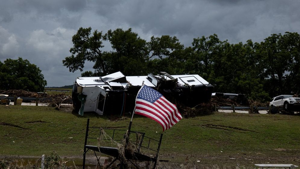
Debris, including vehicles and motorhomes, lies scattered on the ground at the Buckhorn Lake Resort following heavy rains and severe weather in southern Texas in Kerrville, Texas, US, 17 July 2026. Photo: REUTERS
Wildfire smoke blanketed the eastern US from the Great Lakes
to Washington, DC on Friday, floodwaters tore through Texas's Hill Country for
a third day, and new fires erupted in the Pacific Northwest overnight, with 68
large blazes now burning in 15 states.
Millions of Americans faced hazardous conditions and orders
to stay indoors, as the country's summer weather extremes converged on three
fronts at once: a smoke-choked East, rising water in the South, and
fast-spreading flames in the West.
Firefighters are now battling 68 large fires nationwide, up
by nearly two dozen from a day earlier. Some 17 new blazes broke out in the
Pacific Northwest after a run of lightning strikes made it the most active fire
region in the country, according to a summary from the National Interagency
Fire Center.
More than 17,400 personnel, 140 helicopters and four
military C-130 air tanker crews are now deployed across the US to battle
wildfires, with record-low snowpack in the Mountain West and drought pushing
fuel conditions to the type of dry and fire-prone levels normally not seen
until mid-August, according to the NIFC.
Nearly 3.72 million acres (1.51 million hectares) have
burned nationwide so far this year, outpacing last year's mid-July tally by
over 1 million acres.
Jesse Berman, a professor at the University of Minnesota
School of Public Health whose research focuses on how extreme weather affects
health, said simultaneous disasters like those playing out now can make them
more dangerous.
"These are compound events, and that can sometimes make
the impacts of them far worse than what we would experience with any one of
these events individually," Berman said.
University of Pennsylvania climatologist Michael Mann said
the extreme weather events were linked by a wave pattern in the jet stream that
may be a phenomenon known as "resonance." This occurs when large
waves in the jet stream become amplified and trapped, causing extreme weather
to persist over a region for longer periods, creating more chaos.
Mann said his research shows that human-driven climate change
has led to a tripling of these stalled jet stream events since the 1950s.
Climate scientist Jonathan Overpeck, dean of the University
of Michigan's School for Environment and Sustainability, said rising
temperatures are driving disasters through the same basic mechanism, even
though the effects can look opposite.
A warmer atmosphere pulls moisture out of soil and
vegetation more aggressively, which has left Canada's landscape drier and more
fire-prone. At the same time, a warmer atmosphere can hold more water vapor
before releasing it, which is producing the kind of intense, heavy rainfall now
battering Texas.
“What climate change is doing is it's rolling the dice so
that you’re going to get drier conditions and more wildfires at the same time
as you’re going to get more rain,” said Overpeck.
Hazy skies
The smoke from wildfires in Canada has turned skylines from
Minneapolis to Washington orange-brown and pushed dangerous air quality into
the Midwest, Northeast and Mid-Atlantic. Over 100 million Americans -- nearly a
third of the population -- were under some level of National Weather Service
air quality alert, ranging from warnings to refrain from exercising outdoors to
instructions to stay inside out of the smoke.
Chicago's air quality was second-worst in the world on
Friday, according to Swiss air quality technology company IQAir. Local
officials closed parks and beaches along Lake Michigan for the immediate
future, cancelling or moving parks department activities indoors.
The closures limited options for residents without air
conditioning, which according to the Civic Data Atlas comes to about 4% of
citywide households. Temperatures in the city were expected to reach above 90
degrees Fahrenheit (32 degrees Celsius) with heat index values up to 97 F, the National
Weather Service said, activating the city’s community service cooling centers.
Earlier in the week, Detroit, Minneapolis and Toronto ranked
among the most polluted cities on Earth.
A heat dome parked over the Carolinas has set up
northwesterly winds funneling smoke from Minnesota and Canada into the
country's most populous corridor. Rain forecast for the weekend could finally
begin clearing the air.
Texas gets soaked
The NWS forecasts rains to begin easing in Texas on Friday,
with hot and dry weather expected in the coming week.
But the state's Hill Country endured a third consecutive day
of catastrophic flash flooding, with more than 27 inches of rain falling in
some areas since Tuesday, according to the National Weather Service.
Texas Governor Greg Abbott urged residents to remain
vigilant about the dangers of floodwaters. He said at a Friday afternoon press
conference that even if the worst of the rain is behind the state, "the
rivers are going to continue to rise." Forecasters expect some major rivers
to crest over the weekend.
Abbott said the state confirmed that two people died there
in this week's floods: a 65-year-old man swept away in his RV near the town of
Comfort, and a 74-year-old man who drove into floodwaters in Uvalde County.
Rescuers have pulled hundreds of people from rising water this week.
The Texas flooding comes two weeks after the anniversary of
last July's flood on the Guadalupe River, which killed at least 135 people in
the towns that are once again flooding.