



 For all latest news, follow the Daily Sun's Google News channel.


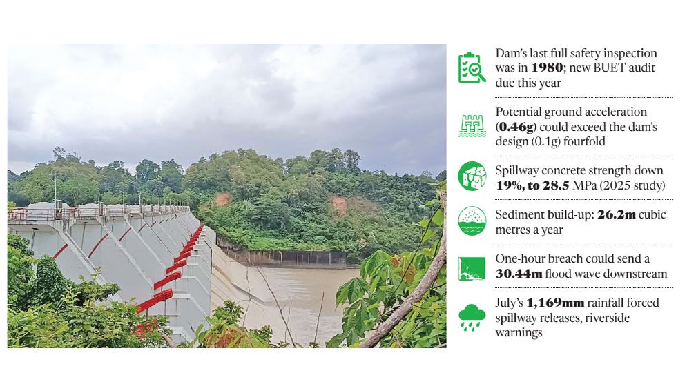
The Kaptai Dam’s last full structural safety inspection was carried out in 1980, its operator has confirmed, as the deaths of more than 1350 people in last month’s glacial-lake flood on the Nepal-Tibet border sharpen scrutiny of the 64-year-old dam and the roughly one million people living downstream in Chattogram.
Built in 1962 across the Karnaphuli River in Rangamati, the earth-filled dam holds back Kaptai Lake, with a capacity of around 6,477 million cubic metres, and powers the country’s only hydropower plant.
Recent studies have flagged compounding risks, from seismic activity and ageing concrete to sedimentation and extreme rainfall.
Seismic exposure
Bangladesh sits at the junction of the Tibetan sub-plate, the Indian Plate and the Burma Plate, according to a joint study by the University of Dhaka and Columbia University.
Dr Mohammad Abdur Rahman Bhuiyan, former director of the Earthquake Research Centre at Chittagong University of Engineering and Technology, said Chattogram, the Hill Tracts and Cox’s Bazar lie directly over major fault lines, with elastic energy along the Sitakunda-Teknaf coastal fault leaving the region highly vulnerable to large earthquakes.
The dam was designed to a seismic factor of 0.1g, but studies indicate the potential Peak Ground Acceleration in the basin could reach 0.46g – over four times that figure.
The nearby Kolabunia, Sitapahar and Bandarban faults are flagged as at risk of reactivation, with research pointing to a magnitude-5.9 earthquake roughly every 30 years in the Sitapahar zone.
A magnitude-5.6 quake in Rangamati in July 2003 produced a PGA of about 0.1g in Chattogram; a larger, closer quake could generate far stronger shaking.
Ageing structure, rising sediment
A 2025 study in the American Journal of Geospatial Technology found the compressive strength of tested concrete in the spillway had fallen 19%, to 28.5 MPa, with tensile stress exceeding 1.5 MPa in places, raising cracking risks.
It attributed this to sediment erosion, fluctuating reservoir levels and extreme rainfall acting together on the dam’s structural integrity.
An estimated 26.2 million cubic metres of sediment settles in the lake each year, reducing its functional capacity.
Dr Aftab Alam Khan, a former Dhaka University geology professor, has noted that the dam’s western section rests on shale rock and hill slopes, where continuous seepage through the foundation is reducing shear stress in the soil and rock – heightening vulnerability during an earthquake.
Chattogram’s 1,169mm of rain over a few days in July pushed Kaptai Lake close to its maximum level of roughly 103.91 feet, prompting the spillway to be opened and warnings issued to riverside residents.
Breach scenarios
A 2025 BUET study using a HEC-RAS 2D model found the speed of a breach, more than its size, would determine downstream flood intensity.
A one-hour breach could produce a 30.44-metre flood wave near the dam – comparable to a nine- or ten-storey building – with water reaching 25.2 metres at Chitmorom Pagoda and 22.8 metres at Godown Bridge in Rangunia.
A three-hour breach would bring somewhat lower but still severe levels at the same points, while a five-hour breach would ease the impact downstream to around 3.2 and 1.7 metres respectively.
Noor Ahmed Al Muqtadir, lead researcher on the BUET study, told the Daily Sun that a rapid breach would send water downstream at maximum speed given the high hills flanking the dam, comparing the risk to the Nepal disaster.
Citing Libya’s 2023 Derna dam collapse, he said ageing infrastructure, heavy rainfall, poor maintenance and weak early-warning systems could combine to devastating effect.
Earthquake specialist Dr Humayun Akhter said the earthen dam could collapse in a major earthquake, unleashing the lake’s water onto Chattogram and potentially paralysing the port through severe sedimentation.
Karnaphuli Hydropower Station Manager Mahmud Hasan said a Dam Safety Audit with BUET is expected to begin this year.
Experts have called for real-time micro-earthquake monitoring, sediment management, structural rehabilitation, seepage tracking, and a comprehensive Emergency Action Plan covering early detection, warnings, evacuation routes, shelters and drills.