




 For all latest news, follow the Daily Sun's Google News channel.


Teesta and Brahmaputra erosion exposes disaster response gaps
Kongkon Karmaker
Published: 04 Jul 2026, 12:55 PM
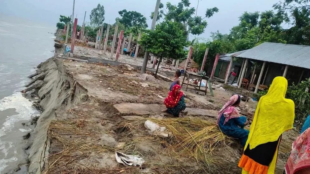
Photo: Collected
Over the past few weeks, attention across northern Bangladesh remained fixed on a single figure — the Teesta River's water level at Dalia Point. Each time it rose above the danger mark, flood warnings were issued. Each time it fell below the threshold, many assumed the worst was over.
But for thousands of families living along the Teesta and Brahmaputra rivers, the greatest devastation began only after the floodwaters receded.
While rising water displaced communities across Rangpur, Kurigram, Lalmonirhat and Gaibandha during the final week of June, the rapid fall in river levels triggered severe riverbank erosion, destroying homes, schools, roads and farmland. The latest disaster has once again exposed a major weakness in Bangladesh's disaster management system, which is better equipped to respond to flooding than to prevent post-flood erosion.
Rapid fluctuations worsen erosion risk
According to the Bangladesh Water Development Board (BWDB), the Teesta experienced dramatic fluctuations in late June.
The river crossed the danger level at Dalia by one centimetre on 23 June before dropping below it the following day. However, heavy rainfall in upstream areas of India's West Bengal and water released through the Gajoldoba Barrage pushed the river to seven centimetres above the danger mark by 28 June.
Water levels fluctuated sharply on 29 June before falling 30 centimetres below the danger level the next day, followed by another 13-centimetre drop within 12 hours.
BWDB officials said such rapid changes, driven by upstream rainfall and barrage operations, have become increasingly common. Engineers warn that although rising water causes flooding, it is the sudden fall afterwards that often triggers the most destructive riverbank collapses.
Floods subside, erosion intensifies
Flooding is the most visible stage of a disaster, with submerged homes, inundated roads, closed schools and displaced families dominating public attention.
However, experts say the most permanent losses frequently occur after the water begins to recede.
As floodwaters retreat, saturated riverbanks lose the hydraulic pressure that temporarily stabilises weakened soil. Large sections of land subsequently collapse into the river in a process known as drawdown erosion, causing extensive land loss days after flooding subsides.
This pattern unfolded across several northern districts during the past week.
Lalmonirhat loses homes as riverbanks collapse
In Aditmari and other erosion-prone areas of Lalmonirhat, residents who had prepared for flooding instead watched the river consume their land after water levels dropped.
In Rajarhat's Ramhori and Chatura villages, geo-bags protecting the eastern riverbank failed as currents strengthened during the recession.
Within days, at least 25 homes in Ramhori Mouza had been washed away. Families, including those of Idris Ali, Shahidul Haque and Ataul Islam, lost their homes, while more than 50 additional structures, including schools and places of worship, remain at risk.
Residents alleged that contractors installed geo-bags during the monsoon instead of completing protective works during the dry season, arguing that emergency measures consistently arrive only after erosion has already begun.
Gaibandha records widespread erosion
The same pattern emerged in Gaibandha, where the Teesta fell by 76 centimetres between 29 and 30 June.
Although floodwaters receded, erosion intensified rapidly.
BWDB officials reported active erosion at around 25 locations across Sadar, Sundarganj, Fulchhari and Sadullapur upazilas.
Local authorities estimated that more than 800 families lost their homes over the past week, alongside extensive losses of agricultural land.
In Fulchhari's Fazlupur Union, the Brahmaputra River swept away a government primary school and several hundred bighas of cropland, with local representatives describing entire char settlements disappearing within days.
Kurigram faces continuing losses
In Chilmari upazila of Kurigram, four consecutive days of erosion along the Brahmaputra destroyed around 60 houses and hundreds of acres of farmland.
Six electricity poles also collapsed into the river, disrupting power supply to around 400 households.
Officials said approximately 850 families in the union have lost their homes to erosion over the past two years, with the latest destruction representing only the newest phase of an ongoing crisis.
Rangpur embankment protection fails
In Gangachara upazila of Rangpur, erosion threatened critical infrastructure after around 150 metres of embankment protecting the Second Teesta Bridge collapsed.
The failure occurred after a bamboo piling structure installed less than six months ago gave way under the season's first major flood surge.
At the same time, fluctuating river levels left nearly 4,000 families waterlogged across six unions.
Local representatives said timely reinforcement using geo-bags could have reduced the damage, but the materials arrived only after significant erosion had already taken place.
A recurring disaster cycle
Engineers and water experts said the sequence of events was entirely predictable.
Across affected districts, officials described the same cycle: heavy upstream rainfall, rising rivers, flooding, rapid recession and extensive erosion.
Despite this well-established pattern, disaster management continues to focus primarily on flood relief, while erosion prevention remains reactive.
Geo-bags are often deployed only after cracks appear, temporary repairs replace permanent engineering solutions, and vulnerable communities are forced to rebuild year after year as major river training projects remain incomplete.
Frustrated by repeated losses, many residents have begun constructing their own flood protection structures.
In Gangachara's Bairati area, villagers pooled labour and local resources to build nearly five kilometres of embankment, later extending it by another two kilometres.
The embankment successfully withstood last year's floods, but fresh cracks have already appeared this monsoon.
Authorities have supplied only around 200 geo-bags, far fewer than residents believe are necessary to protect the structure throughout the rainy season.
The initiative reflects a growing trend across northern Bangladesh, where communities are increasingly forced to provide protection that official agencies have failed to deliver in time.
Heavy rainfall may worsen the situation
The Flood Forecasting and Warning Centre (FFWC) has forecast further heavy rainfall across Rangpur Division and upstream areas of West Bengal during the first week of July.
Water levels in the Teesta and other northern rivers are expected to rise again, increasing the risk of fresh flooding in Nilphamari, Lalmonirhat, Kurigram, Rangpur and Gaibandha.
Experts warn that if recent trends continue, every new flood pulse is likely to be followed by another wave of destructive erosion.
Forecasting alone cannot save river communities
Bangladesh has made significant progress in flood forecasting over the past two decades, providing earlier warnings than ever before.
However, the events of the past week demonstrate that forecasting alone cannot protect riverbank communities.
Floods are temporary. Riverbank erosion is permanent.
Flooded homes can often be repaired and reoccupied. Homes swallowed by rivers are lost forever. Flooded farmland may recover within weeks, but land consumed by erosion rarely returns.
Experts say that unless erosion prevention receives the same priority as flood forecasting — through timely riverbank protection, year-round maintenance and the implementation of long-delayed river training projects — the destructive cycle will continue.
The rivers will rise, warnings will be issued, floodwaters will recede, and with each passing season, more land in northern Bangladesh will quietly disappear beneath the rivers.